← Baroque Mughals and Companies
 Click to enlarge
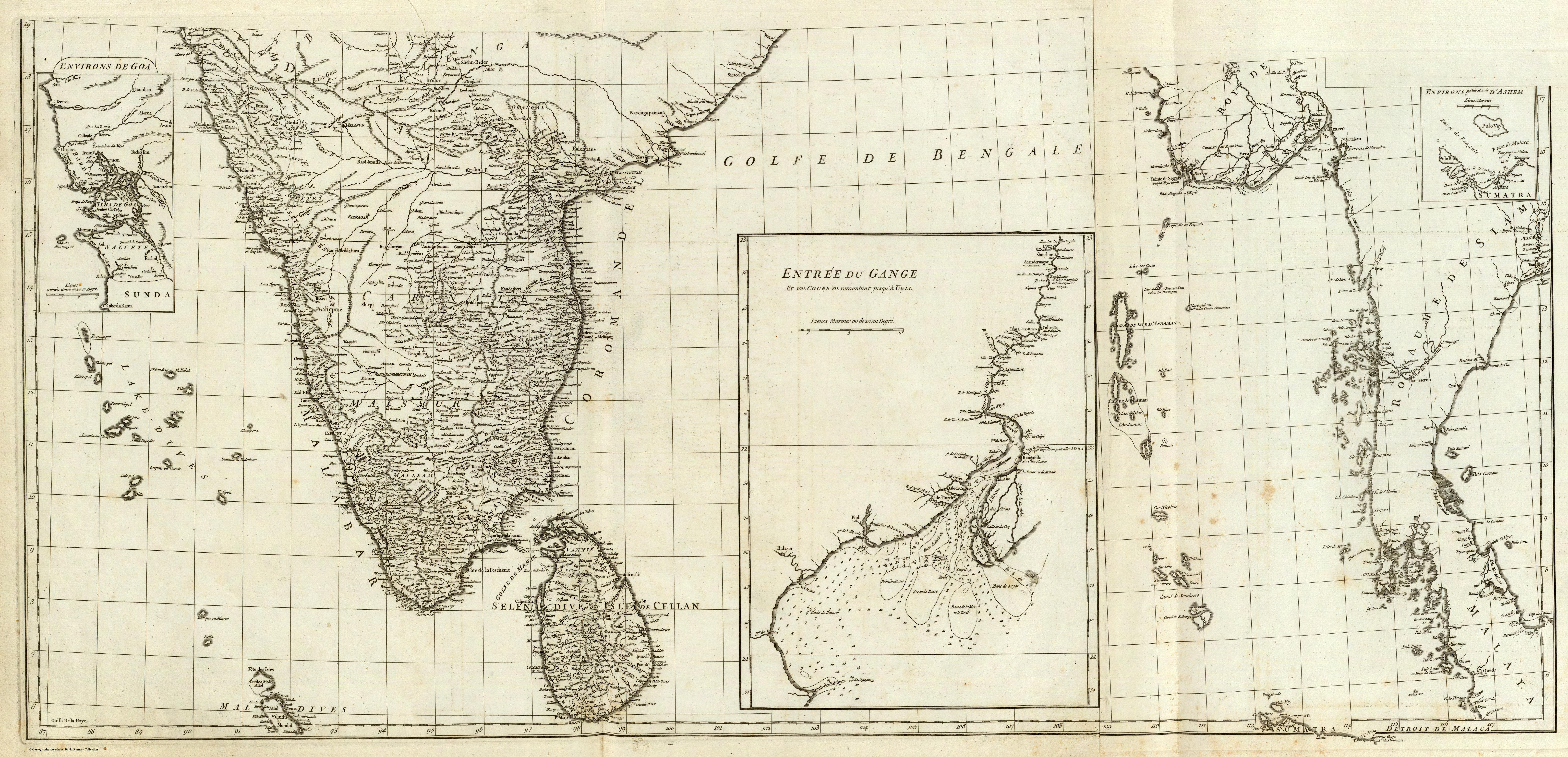
Carte de l'Inde. Southern section
The map titled "Carte de l'Inde. Southern section" was authored by Jean Baptiste Bourguignon d'Anville in November 1752 and published by J.B.B. D'Anville. It measures 104 cm in width and 50 cm in height and is engraved by Guillaume Delahaye. This map is part of a world atlas, specifically focused on the southern section of India and surrounding regions, with a scale of 1:3,100,000.
Composition and Medium
The map is engraved on two sheets and mounted as one. It employs pictorial relief to depict geographical features, using hachures to represent elevation. The map is hand-numbered "17" on the verso, indicating its sequence in the atlas. The detailed engraving is a testament to the precision and skill of 18th-century cartographic techniques.
Style and Subject Matter
D'Anville's style is characterized by clarity and directness, which was considered modern for his time. The map covers the southern part of the Indian subcontinent, showcasing regions such as modern-day India, Bangladesh, and parts of Southeast Asia. Insets include "Environs de Goa," "Entree du Gange," and "Environs d'Ashem," providing detailed views of these specific areas. The map also includes soundings in the Ganges delta, indicating navigational depths.
Cultural and Historical Context
This map was created during a period of increased European interest in Asia, particularly by trading companies like the French East India Company. The detailed depiction of coastal regions and trade routes reflects the economic and colonial interests of the time. D'Anville, known for his scholarly approach, incorporated the best available geographic knowledge from various sources, making his maps highly valued by contemporaries and later copied extensively by the English and others.
Significant Features
- Insets: The insets provide detailed views of strategic locations such as Goa and the Ganges delta, areas of significant commercial and strategic interest during the colonial period. - Inscription and Labels: The map includes numerous labels of cities, regions, and physical features, reflecting the geopolitical understanding of the era. - Relief and Soundings: The pictorial relief and soundings in the Ganges delta demonstrate an emphasis on both geographical and navigational information. - Grid System: The map uses a grid system, possibly indicating longitude and latitude, which was a relatively advanced feature for maps of this period.
Pub Information
- Atlas Information: This map is part of an atlas containing maps dated from 1743-1771. Each map was tailored to individual customers, indicating the bespoke nature of D'Anville's work. - Pub List No: 2603.000 - List No: 2603.021 D'Anville's work remains a significant historical resource, reflecting the cartographic knowledge and colonial ambitions of 18th-century Europe. His maps, such as this one, offer valuable insights into the geography and political landscape of South Asia during this period.