 Click to enlarge
India Showing Civil Divisions — Boundaries of Pakistan (Case A / Case B)
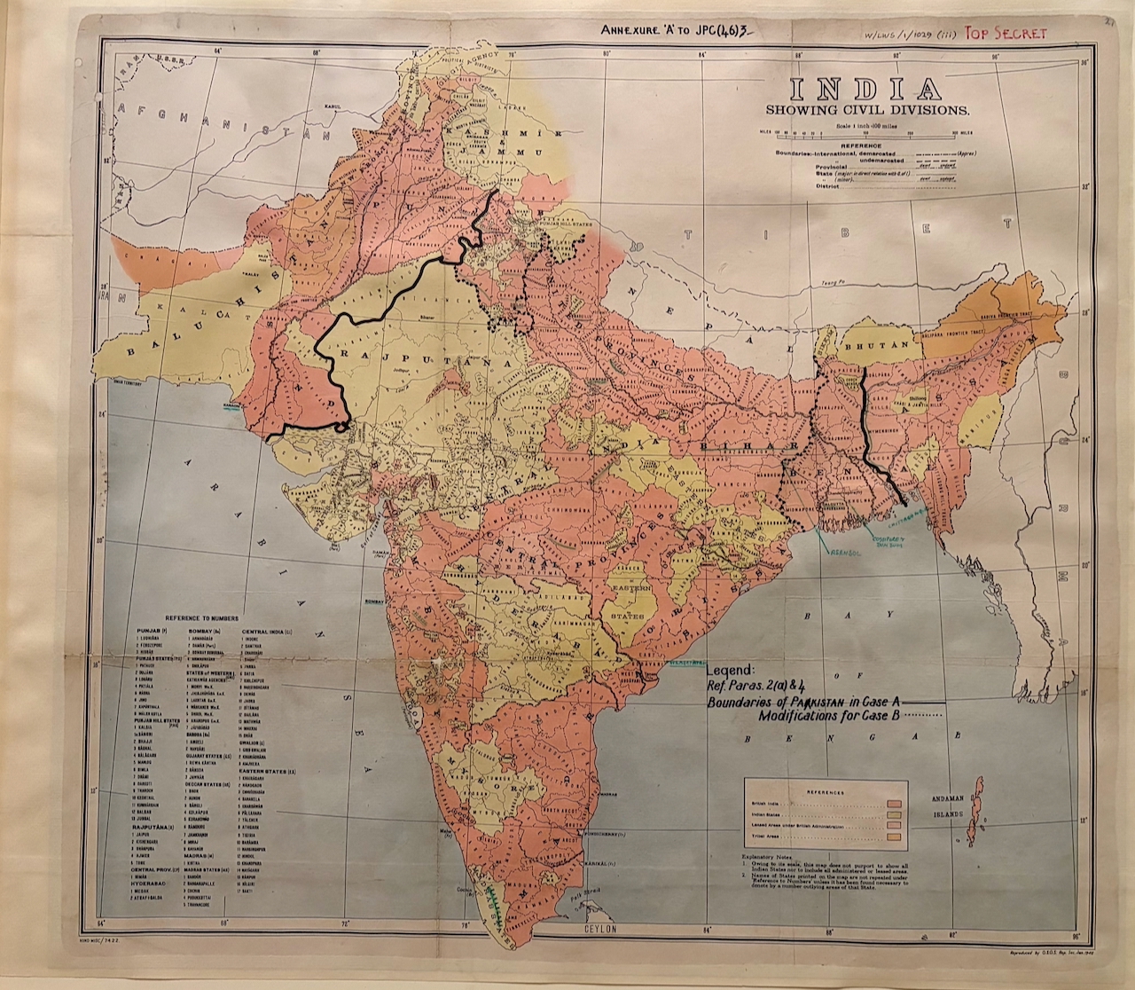
A Top Secret British staff map from the planning of the Partition of India — a standard Geographical Section, General Staff base map of India Showing Civil Divisions, overprinted with two proposed boundaries for a future Pakistan ("Case A," and a dotted "Modifications for Case B"). It is the European gaze at its terminal point: the departing power, in secret, drawing the line that would divide the subcontinent.
Authorship and object
The base is a standard India Showing Civil Divisions sheet reproduced by the Geographical Section, General Staff (G.S.G.S.) — the British War Office's mapping body — at one inch to a hundred miles. It has been overprinted as "Annexure 'A' to JPC(46)3" and stamped TOP SECRET in red: an appendix to a 1946 British planning paper (the JPC prefix indicating a Joint Planning–level committee). Following the legend's reference to "Paras 2(a) & 4," a heavy line marks the "Boundaries of Pakistan in Case A," with a dotted line for the "Modifications for Case B."
A contingency, not yet a border
This is a planning document, drawn roughly a year before the actual partition line. It sets out alternative schemes — two "cases" — for where a Pakistan might be bounded in the north-west (around the Punjab, Sind and Baluchistan) and the north-east (around Bengal and Assam): the kind of exercise British officials undertook in 1946 as they weighed a "full" Pakistan against a reduced, "moth-eaten" one and assessed the defence and administrative consequences of each. The definitive boundary would not be set until Sir Cyril Radcliffe's award of August 1947.
The gaze
No map in this collection shows the European gaze so nakedly as power. Four centuries after a Portuguese atlas claimed the Indian Ocean in gold, a British staff officer sits with a coloured base map and divides the subcontinent in secret — its provinces and peoples sorted, provisionally, into "Case A" and "Case B." Lines drawn in exercises like this would within a year harden into a border across which one of the largest and most violent migrations in human history took place. Here the act of mapping India and the act of disposing of it become, explicitly, the same act. It is the fitting close to the story this collection tells: the gaze that began by imagining India ends by partitioning it.