 Click to enlarge
Where Pakistan and India Come Face to Face — the Punjab
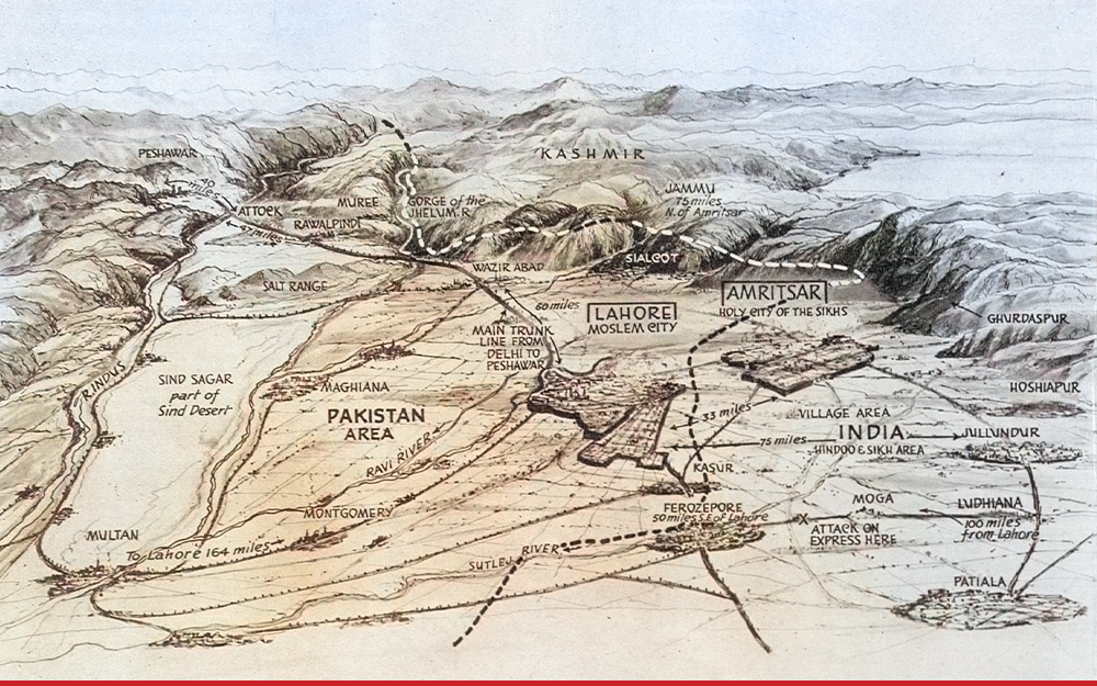
A coloured bird's-eye panorama of the newly partitioned Punjab, drawn by Percy Home for the British weekly The Sphere in September 1947. Looking across the plains toward the Himalaya, it sets a labelled "Pakistan Area" against "India," Lahore the "Moslem City" against Amritsar the "Holy City of the Sikhs," with the new boundary dotted between them — the partition frontier rendered as dramatic spectacle for readers in London, a month after independence.
Authorship and object
A panoramic view drawn by the artist Percy Home and published in The Sphere (London) on 13 September 1947 — barely a month after the partition of British India. It is the cartographic element of an illustrated news page, "The Two-Way Exodus in the Punjab," which reported the mass migration and communal violence that followed independence; the page's photographs and captions are not reproduced here.
A map in dramatic perspective
Rather than a plan, Home adopts a low, tilted viewpoint looking north-east across the Punjab plains toward the mountains of Kashmir, so the land recedes in theatrical depth. The Indus, Ravi, Sutlej and Jhelum thread the foreground; the Delhi-to-Peshawar trunk line and the roads are drawn as the arteries of flight; and the new boundary runs as a bold broken line between "Pakistan Area" and "India (Hindoo & Sikh Area)." Cities are labelled by their communal charge — Lahore the "Moslem City," Amritsar the "Holy City of the Sikhs" — and small notes fix the violence to the ground, marking distances and an "attack on express here."
The gaze
This is the journalistic version of the European gaze, and a troubling one. A British magazine renders the catastrophe that its own government's partition had just unleashed as an absorbing panorama for readers at home — a human disaster in which all three communities both suffered and inflicted terrible violence, flattened into a dramatic vista to be taken in at a glance. (On the full page, that framing turned frankly lurid and one-sided; isolated here, the map shows the impulse in purer form.) It rhymes with Abington's panorama of the 1857 Rebellion and Mercier's wartime newspaper map — India as spectacle and news — and it pairs exactly with the secret 1946 staff map: there, the line drawn in private by the departing power; here, that same line a few months later, its consequences laid out as popular illustration. The gaze that opened this collection by imagining a coastline closes it by watching, from a comfortable distance, the country it had spent four centuries mapping torn apart along a border drawn from outside.